A Geoglyphic Study of the Indonesian Pyramids West Java
by Arthur Faram
The Faram Research Foundation
This paper details the results of a geoglyphical study of the newly discovered Lalakon and Satahurip Pyramids in West Java, Indonesia. The origin of these structures will be studied using spherical geometry to follow the bearings created by the ridge detail designed into the pyramid. The practice of using the geometry of ancient structures to release hidden details of their origins is not a new practice. This practice has been handed down through secret societies since even before the building of the Egyptian pyramids. I call the re-discovery and application of this ancient practice Geoglyphology.
The function of Geoglyphology, as it relates to Archeology, is to expand both the search area and the knowledge base available to the Archaeologist. Until now the majority of the information available to the Archaeologist is gleaned from the information recovered at the dig site. In recent years it has been discovered that a great majority of the ancient architectural, monolithic and geoglyphic structures built around the world have something in common. That commonality is that the structures were aligned in such a manner that the study of their linier alignment unveils a much larger story and immensely expands the data available to the archeologist and the related disciplines.
Data recovered from sites that included Geoglyphology in their study included; Obtaining the geographical range of the culture being studied, the level of sophistication that existed in relation to their understanding of mathematics and geometry, their knowledge of world geography, the discovery of other archeological sites that were unknown prior to the studies, and the dating of the culture itself from the data collected at related offsite locations identified by the alignments at the dig site. The success of these studies shows that Geoglyphology can play a major role in expanding the knowledge base available to the Archeologist. More information on Geoglyphology can be found at www.thefaramfoundation.com .
Note: The calculations performed during the writing of this paper required the use of a special software called "Google Earth". Google's software is able to calculate true spherical bearings on the curved surface of the earth and then display them correctly on a flat plane.
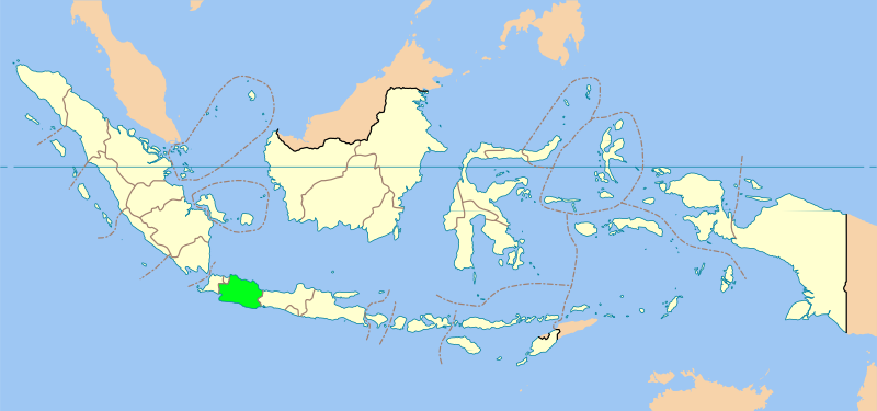
INDONESIA
Map of Indonesia
(West Java, the location of the Pyramids, is in green.)
West Java has passed down, through their folklore, that the Egyptians once visited their island. They even have a stone carving that supposedly depicts an Egyptian bowing down to an Indonesian. The early presumption of a Pyramid existence in this country began with a series of Turangga Seta expeditions conducting mapping of reliefs in Candi (Temple of) Penataran (Blitar, East Java) from 2007 to 2009. The colonization of Indonesia by the ancient Egyptians is fully documented by Sir Thomas Stamford Raffles in his volume, The History of Java - John Murrey Publishing, London - 1830. Tomb paintings and writings show that the Egyptians were trading down the Red Sea and into the Indian Ocean before 2000 BC. They made regular excursions to Lebanon before 2500 BC for cedar. During the reign of female pharaoh Hatshepsut (1503-1482 BC), ships 90 to 100 feet long were sailing to and from the Land of Punt... David Pratt, Aug 2011- http://www.davidpratt.info/americas1.htm .
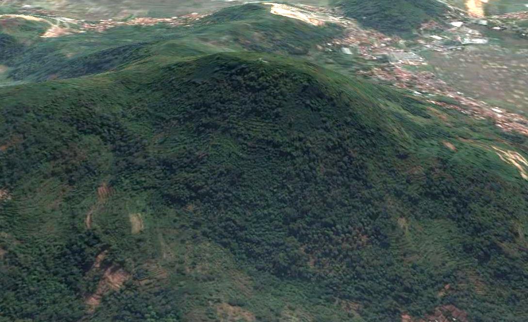
THE LALAKON PYRAMID
The Lalakon Pyramid - West Java
(06 57'29.11"S 107 31'15.31"E)
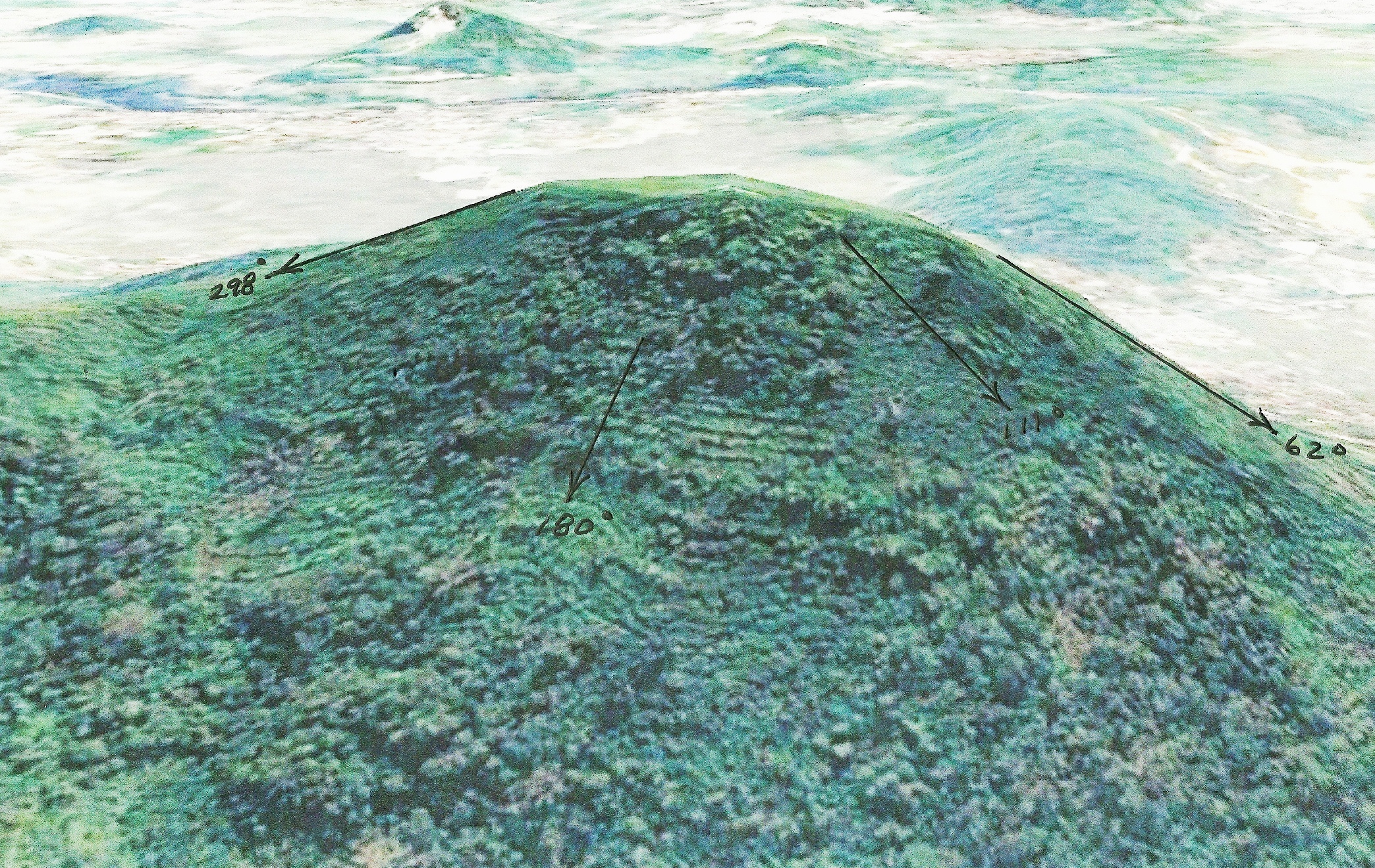
The Lalakon Pyramid is rather dismal sight in comparison with most other pyramids of the world. The pyramid has degraded from attacks by the monsoons that are prevalent in the area. One thing that detracts from its majesty is the fact that, just like the Bosnian Pyramids, this pyramid is cut out of a ridgeline. This was really quite brillient. This would allow the builder to carry the unused earth that was removed from the structure downhill. That appears to be what was done here. On the northeast side of the pyramid there appears to be an unnatural amount of earth in a continuous slope down to the valley below.
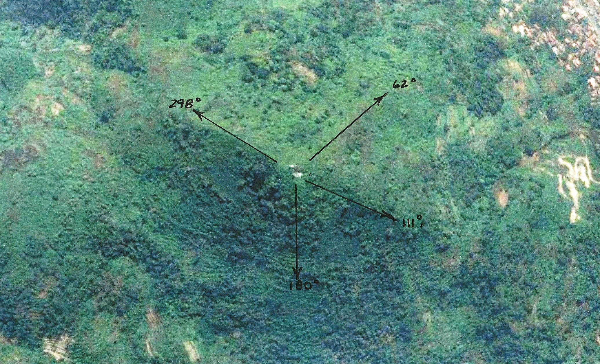
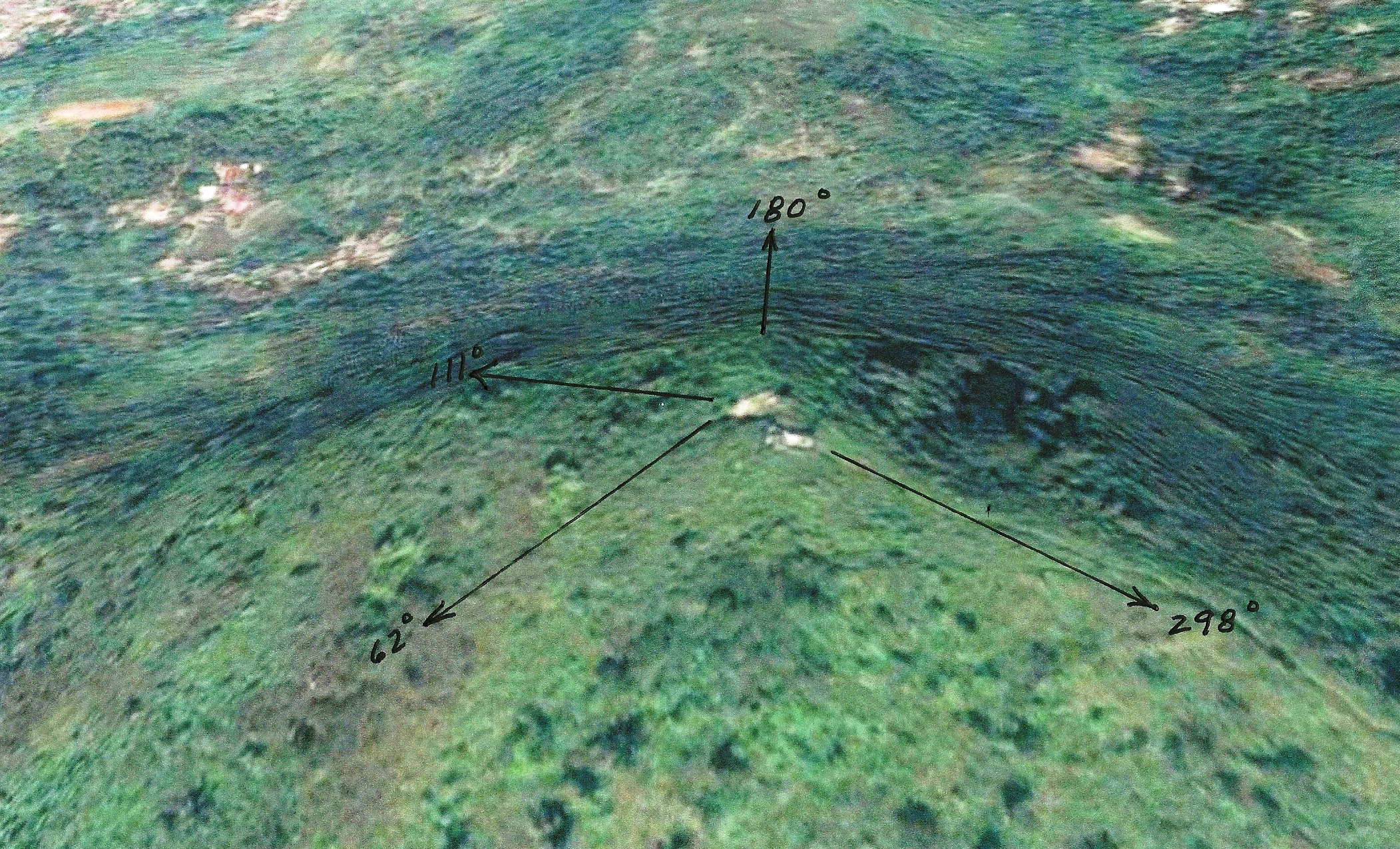
Our research shows that the pyramid does have four ridges but that they are not symmetrical. Experience has shown that non-symmetrical pyramids are primarily used to denote direction rather than being constructed as a monument. These directional ridges are used to outline a territory, convey a message, or to memorialize where the builder was from. Since the Lalakon Pyramid was not constructed of stone, or covered with a stone facing, the earth has worn away the ridges over the years until it is barely recognizable as a pyramid. This makes it more difficult to determine the location of the ridges from which to determine the directional bearings. These bearings will indicate the territory, or important points, which the builder intending to communicate.
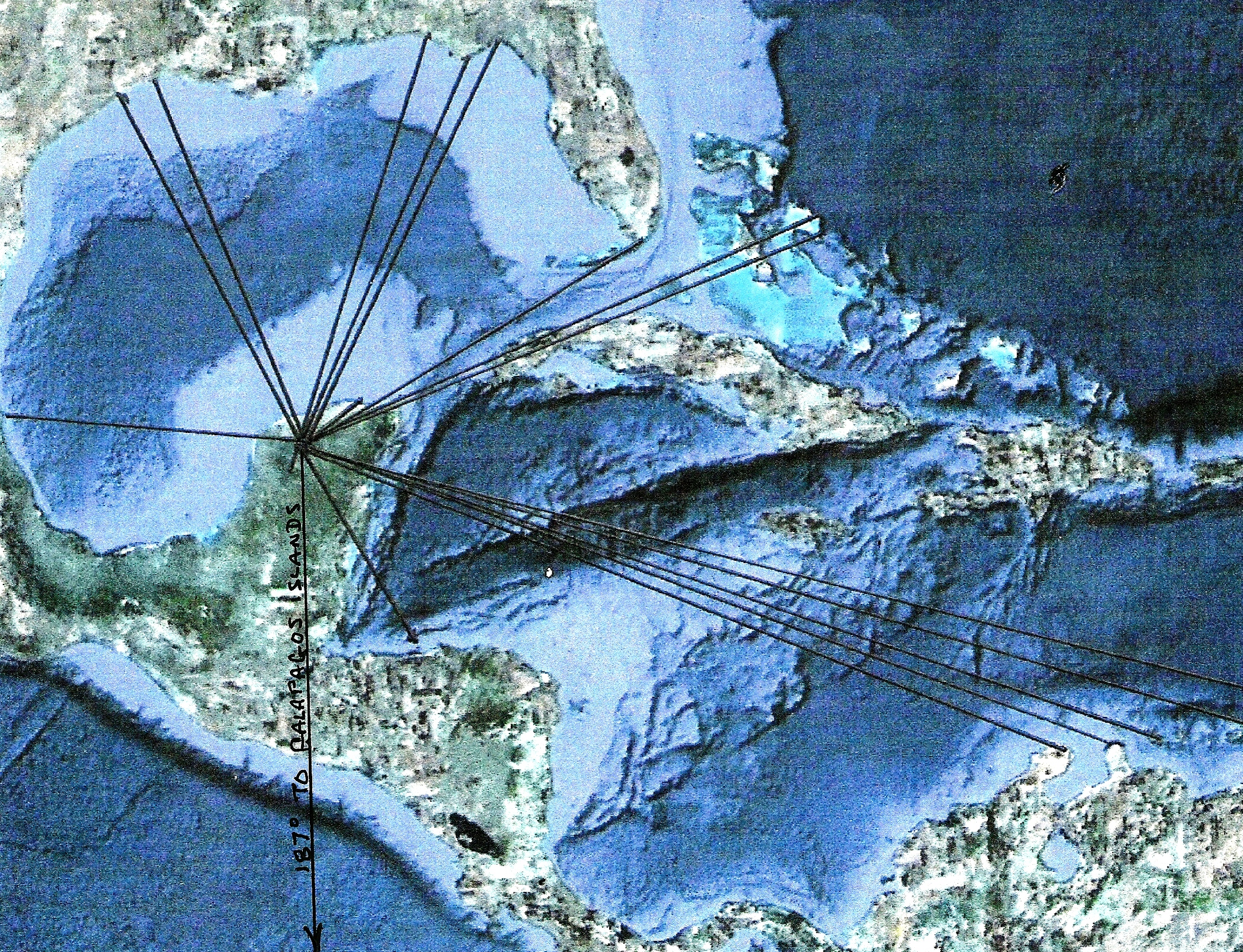
In this case a topographical study was performed to determine the highest points on the pyramid. If there are ridgelines they will then become visible. Some ridges may not be perfect due to erosion but the original line can be determined. After close examination it was determined that there were four ridges on the pyramid which were aligned along the bearings of 62, 111, 180, and 298 Degrees. Another confirmation that this is a legitimate geoglyph is the fact that it contains a cardinal bearing in its makeup. This is the protocol for verifying that this is a true geoglyph. It was now necessary to use special software, Google Earth, which computes using true north for the full distance of the radials to the intended destination. That route cannot be plotted on a flat map because when you transition a map from a sphere to a flat plane, severe distortion occurs. Magnetic bearings cannot be used due to the magnetic deviation that occurs when using magnetic headings. The results of our findings follow.
The Lalakon Pyramid From Above
The North Side of the Lalakon Pyramid
The South Side of the Lalakon Pyramid
Endpoints for the bearings displayed in the above photos.
062 Degree Radial - So Tip of Baja
111 Degree Radial - Galapagos Islands, Eastern Pacific
180 Degree Radial - Southern Tip of South America
298 Degree Radial - Luxor, Egypt
The four endpoints listed above most likely do not mean much to the reader, unless you have read my book Ancient Signposts. As the following information will attest, the Lalakon and Salahurip pyramids, and most likely the many other earthen pyramids in Indonesia, have ties to Egypt. The information presented here has been used for millennia, so these are not new concepts. The information in my book, which was published before the Indonesian pyramids were known to me, is additional validation of the information presented here. The intersection of the points concerning two or more geoglyphs is not unusual since many termination points are used many times over in presenting this ancient information. The results that follow show an intentional conveyance of information connecting Egypt and the Americas. The time period in which the Indonesian pyramids were built can only be determined by an onsite excavation, which I highly recommend.
One might ask; why do Indonesian pyramids point to Egypt and territories in the Americas? I have previously released studies, on the various parts of a worldwide puzzle of ancient territories, and am currently writing a book on the subject. In this study I will present the short version of this phenomenon and then verify the information in the diagrams and text. During our research a pattern has been developing which seems to align with Plato's statement that, in the beginning, there were certain territories that were assigned to the ancient gods. (For this presentation I will presume "Gods" to mean; those who have more knowledge than we do.) These statements can be found in the Plato's "Critias". A portion of that text is presented here:
..."In the days of old the gods had the whole earth distributed among them by allotment. There was no quarrelling; for you cannot rightly suppose that the gods did not know what was proper for each of them to have, or, knowing this, that they would seek to procure for themselves by contention that which more properly belonged to others. They, all of them by just apportionment, obtained what they wanted and peopled their own districts; and when they had peopled them they tended us, their nurslings and possessions, as shepherds tend their flocks, excepting only that they did not use blows or bodily force, as shepherds do, but governed us like pilots from the stern of the vessel, which is an easy way of guiding animals, holding our souls by the rudder of persuasion according to their own pleasure; thus did they guide all mortal creatures. Now different gods had their allotments in different places which they set in order. Hephaestus and Athene, who were brother and sister, and sprang from the same father, having a common nature, and being united also in the love of philosophy and art, both obtained as their common portion this land, which was naturally adapted for wisdom and virtue; and there they implanted brave children of the soil, and put into their minds the order of government; their names are preserved, but their actions have disappeared by reason of the destruction of those who received the tradition, and the lapse of ages"....
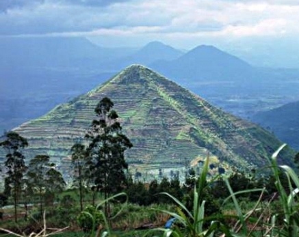
THE SADAHURIP PYRAMID
The Sadahurip Pyramid, Garut, Indonesia
The multiple ridges on the sides can be clearly seen.
(7.179926S 108.041611E)
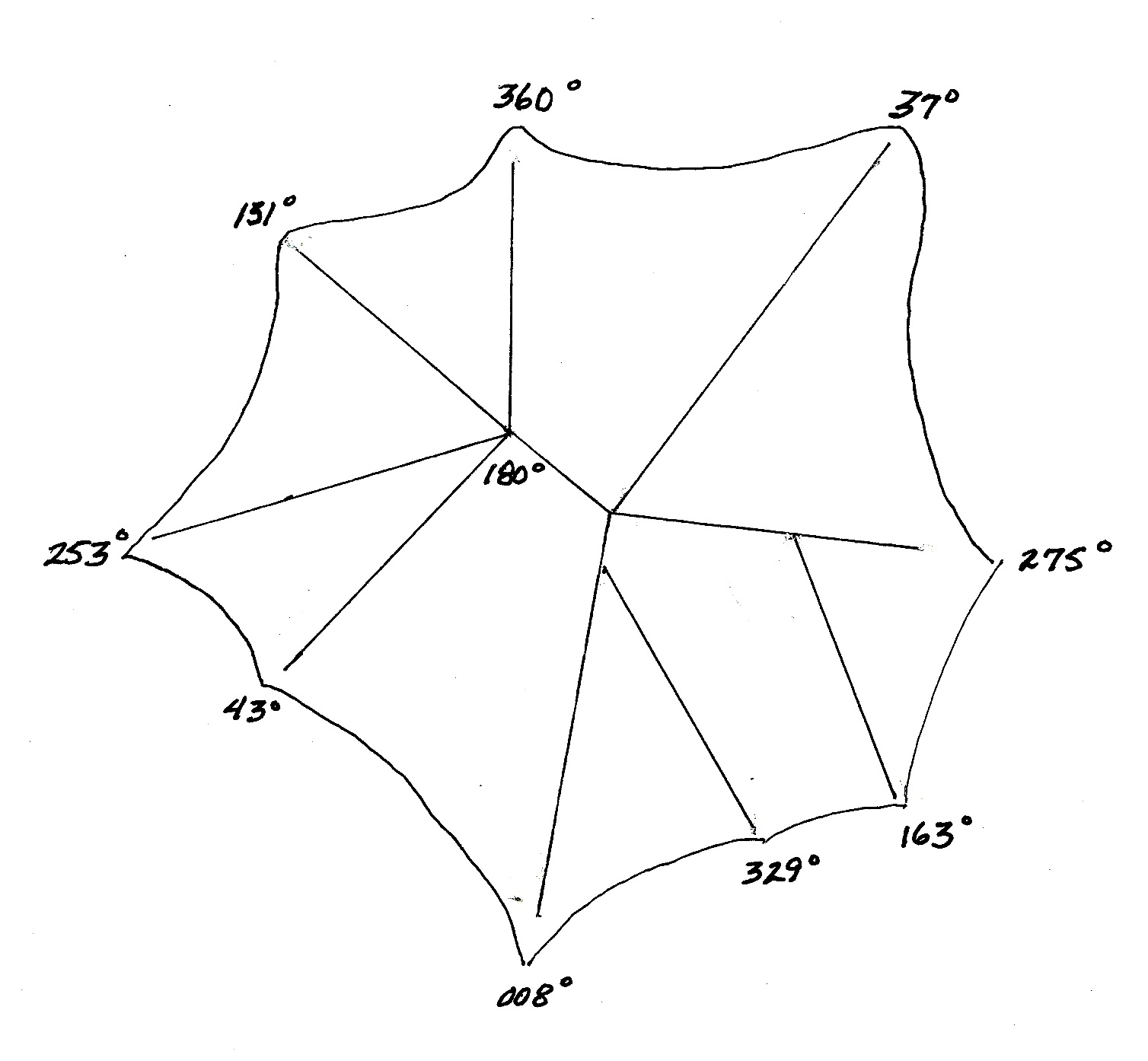
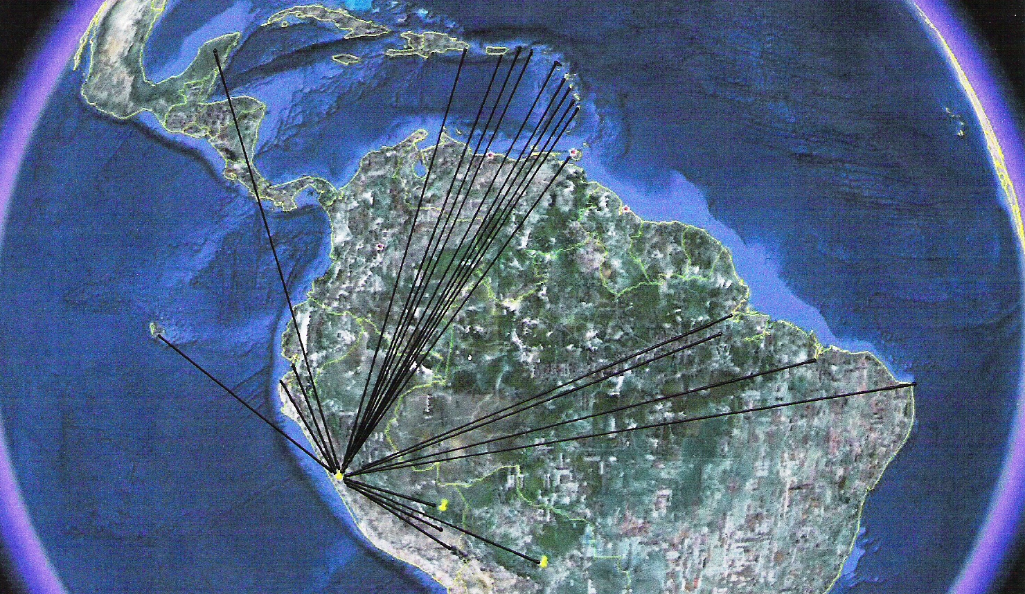
Bearings associated with the Mount Sadahurip Pyramid
(As viewed from above)
Endpoints for the bearings displayed in the above photos.
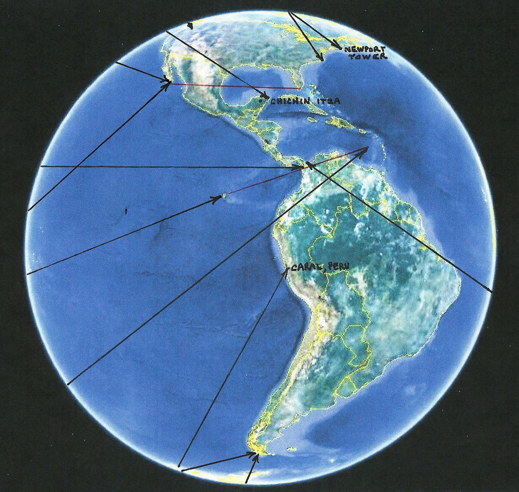
008 Degree Radial - Cape Hatteras - Eastern most point in the North American Territory, later to be the USA.
037 Degree Radial - Northwest Corner of the North American Territory, at the boundary between the US and Canada.
043 Degree Radial - Tip of the Yucatan Peninsula, Mexico - Location of Chichen Itza, the center point for the Mesoamerican territory.
131 Degree Radial - Center of the Meteor Crater associated with the South American Territory, as defined by the Caral, Peru Geoglyphs.
163 Degree Radial - Caral Peru - Center point of the South American Territory.
180 Degree Radial - Southern Tip of South America - Southern point in the South American Territory.
253 Degree Radial - The point Where Panama Meets Columbia (East Side), The border between the Mesoamerican Territory and the South American Territory.
275 Degree Radial - The point Where Panama Meets Columbia (West Side), The border between the Mesoamerican Territory and the South American Territory.
329 Degree Radial - North Tip of Scotland - The Sadahurip pyramid was most likely built before Stonehenge, the current marker, was built.
360 Degree Radial - Newport Island, RI USA - Mentioned in Geoglyphs as old as 7000 years. One of the major survey markers for the North American Territory.
The Sadahurip Pyramid Radial Endpoints
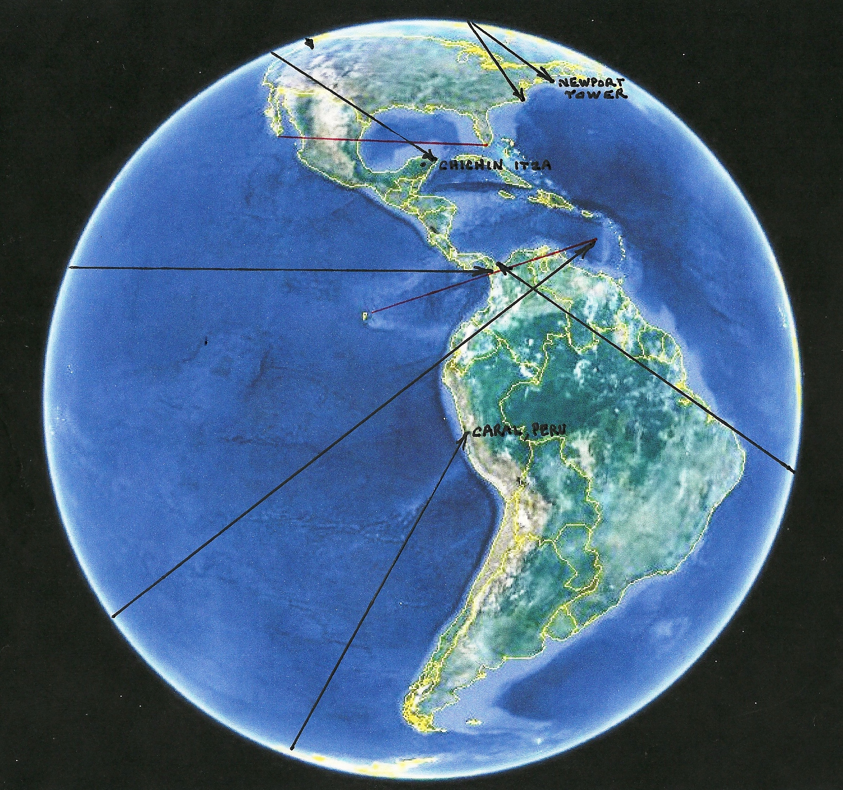
In the previous diagram the curvature of the lines is missing since they were drawn on a flat surface; however, all lines were plotted on a computer before they were placed on the map. If you will refer back to the previous photos showing the radials that make up the three territories, you will see that the center survey point for all three territories of the Americas is pointed out by the Sadahurip Pyramid. In the next photo the radials of both the Lalakon and Satahurip Pyramids, and the Giza 045 and 135 degree radials, are plotted together in one diagram to demonstrate that they are not an anomaly but were carefully crafted to point out a relationship with the three territories of the Americas.
The Lalakon and Sadahurip Pyramid Radials Combined.
OTHER ANCIENT TERRITORIES
The territories that are presented in the following photos are a collection of ancient territories, deciphered by The Faram Foundation research, which are relevant to the story that will unfold concerning the Indonesian pyramids. Full details of these geoglyphs can be found on the websites listed at www.thefaramfoundation.com.
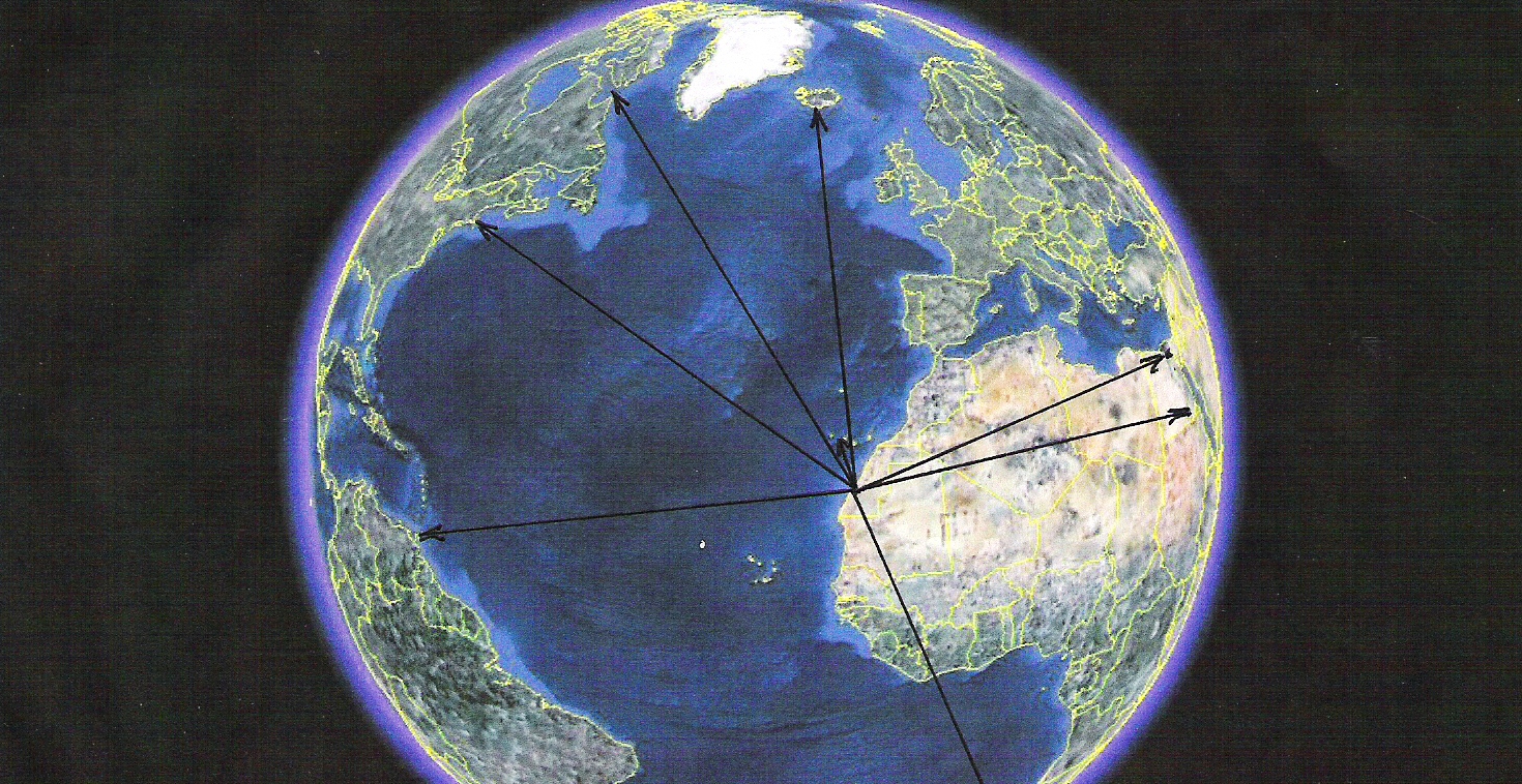
The African (Egyptian) Territory
The Gulfo de Cintra geoglyph is located at the center point of the radials shown above. This geoglyph is over 7000 years old and was the geoglyph that outlined the African territory prior
to the pyramids, located in Cairo, Egypt, being built. Notice that one radial of the Gulfo de Centra geoglyph points to the Island of Newport, RI USA. Newport is also referenced by the Sadahurip Pyrimid in Indonesia, as well as numerous other geoglyphs around the world.
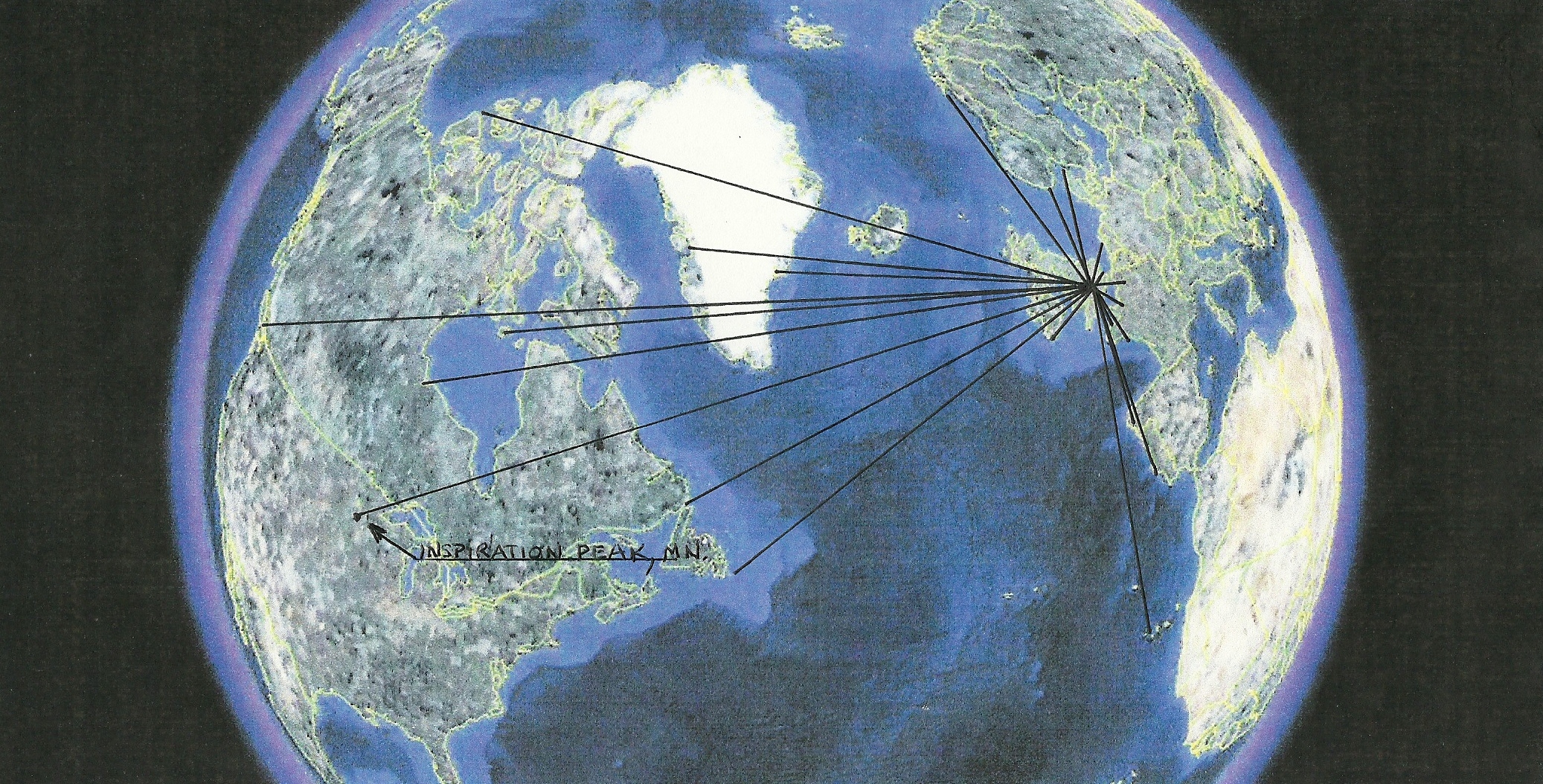
The Stonehenge Territory
(Notice that one radial of the Stonehenge geoglyph points to Inspiration
Peak, the survey marker for the adjoining North American territory.)
The North American Territory
The North American radials are comprised of information deciphered from Newport Tower, RI USA, the Kensington Runestone, MN USA, and Inspiration Peak, MN USA. The southern boundary of the Stonehenge territory lies approximatly where the 073 degree boundary line is depicted. There is one radial which extends outside the Stonehenge Territory to the center point for the adjoining North American Territory, that line terminates at Inspiration Peak, MN. These boundaries were later confirmed when, circa 1821, the Portuguese, an ally in the early colonization of the North America, built the Guimar pyramids on Tenerife Island in the Canary Islands as a geoglyph to validate the endpoints of the ancient North American Territory. This territory later evolved into the USA. Knowing this information imparts true meaning to President Polk's saying that; A country coast to coast is our "Manifest Destiny". The boundaries of the territory shown above were further amended to its current configuration by the Treaty of Hidalgo, after the Mexican American War in 1828.
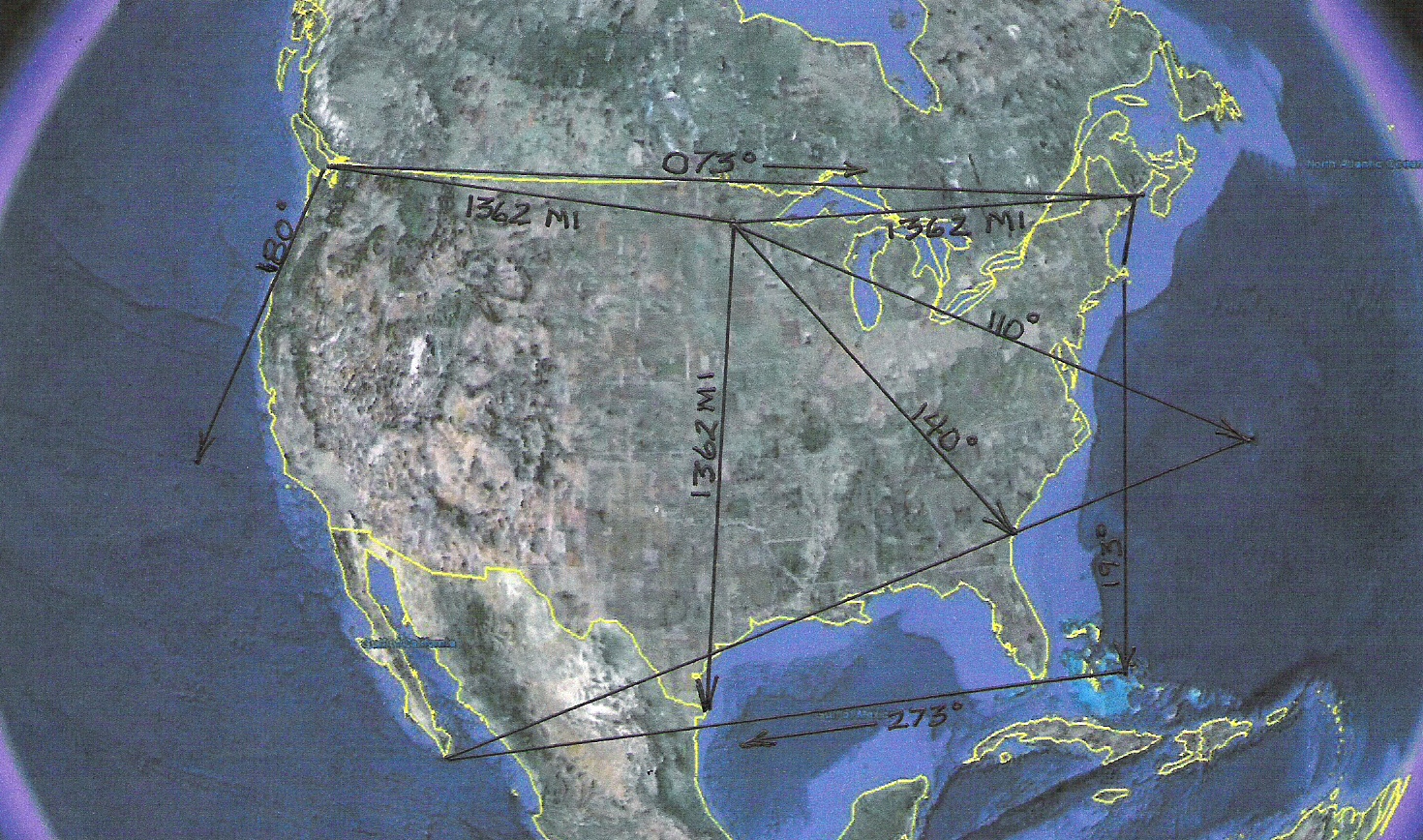
The Mesoamerican Territory
(This territory is deciphered from the Chichen, Itza complex in Mexico. The territory overlaps the
North American Territory but does not claim the adjoining land. It is claiming the Gulf of Mexico.)
The South American Territory
(This territory is deciphered from the Caral Peru complex. Notice that one
radial points to Chichen Itza, the center point for the adjoining territory.)
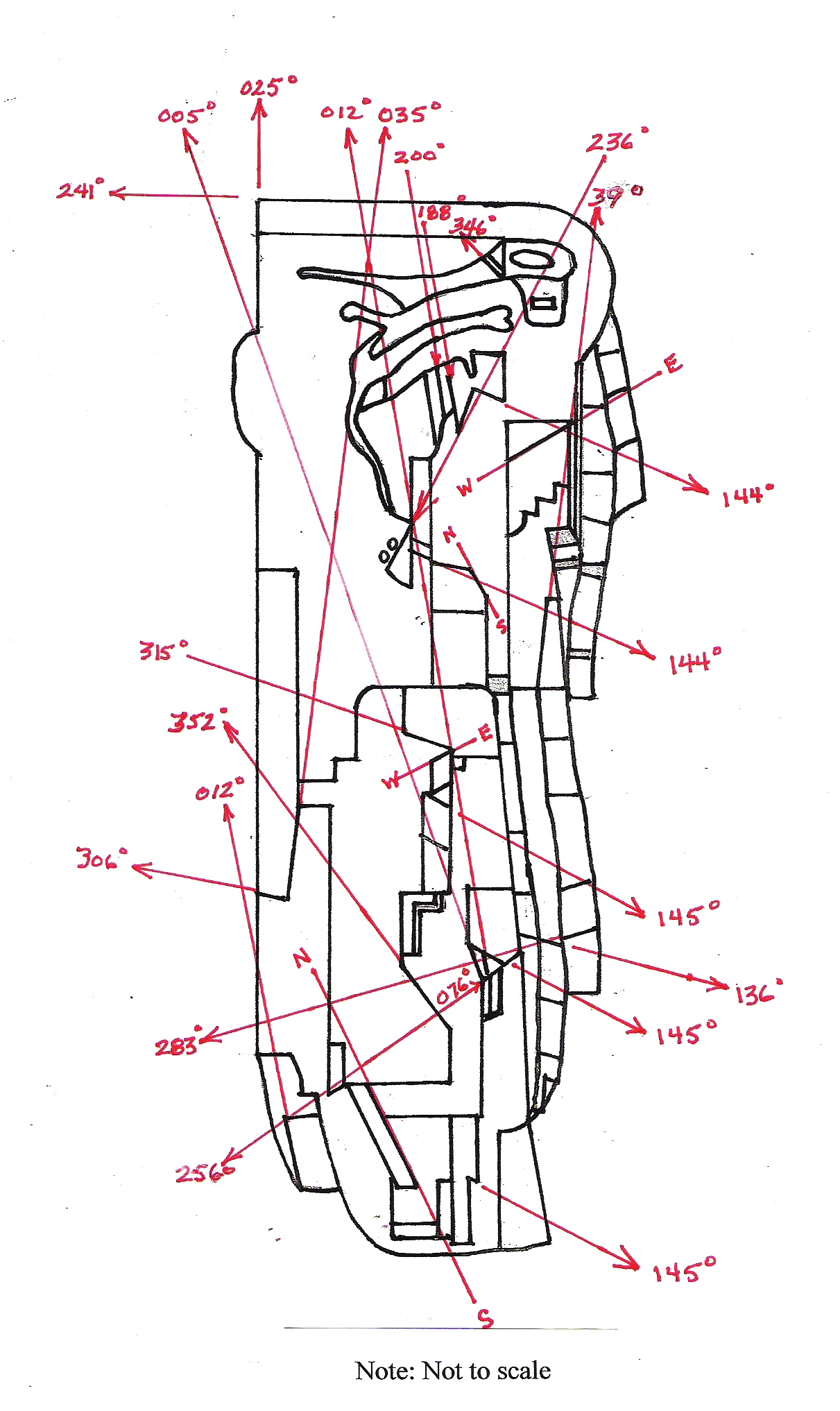
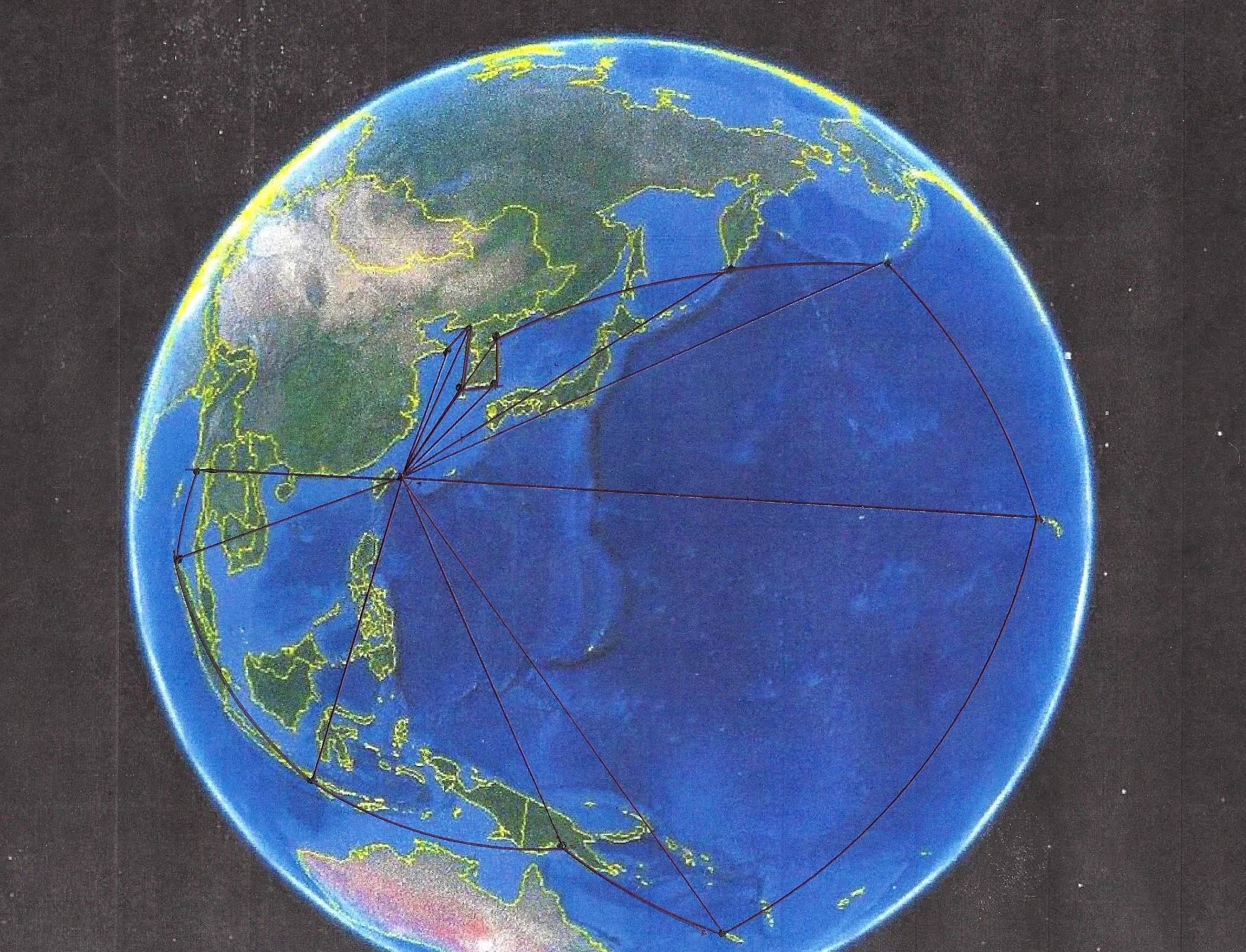
The Japanese Yonaguni Bearings
(It should be noted that the Indonesian Pyramids lay within these Yonaguni Pyramid boundaries.)
The Yonaguni Territory
Our research has shown that some type of worldwide territorial apportionment took place long before the Egyptian pyramids were built. It appears that civilizations that existed prior to the Egyptians were also building monuments and pyramids to outline these ancient territories for posterity. A few examples of geoglyphs which we have discovered, that outline ancient territories, are:
Bosnian Pyramids - (c10,000 BC) These pyramids originally outlined what is now known as Europe, Africa and Canada. This was later amended by geoglyphs placed on the top of two of the pyramids which, coincidently, outlined the original Celtic territory of Europe, Britain and what is now Canada. The Celts were later driven, by other civilizations, west into Western Europe and the Nordic areas. The Bosnian Pyramid is the oldest and largest pyramid discovered thus far. The boundaries that it depicted were apparently so large that they were broken up into the smaller territories of Africa, Europe and Celtic Stonehenge.
Yonaguni Pyramid - (c10,000 BC) This pyramid outlines the same territory which Japan was attempting to re-establish in the Second World War.
Lalakon Pyramid - (Not yet dated by an onsite study.) The construction of this pyramid is very similar to the unusual construction used in the Bosnian pyramids.
Caral, Peru - (c10,000 BC) Outlines the territory known as South America.
Gulfo de Cintra Geoglyph - (Built before 7000 BC) The Gulfo de Cintra geoglyph was the territorial marker for Africa prior to the Giza Pyramid being built. The age of the geoglyph is confirmed by the fact that the Nabta Playa geoglyph in Southern Egypt, which has been dated as being 7000 years old, points to the Gulfo de Cintra geoglyph. The Gulfo de Cintra Geoglyph points back to Nabta Playa.
Inspiration Peak, Minnesota USA - Older than 2900 BC, and outlines the territory now known as the USA. This includes a small portion of Mesoamerica just below the southern border.
The reason the age of Inspiration Peak cannot be determined to be older than c2900 BC is because the oldest confirmed reference to the this marker is Stonehenge (c2900 BC), which points out Inspiration Peak as being the center point of the adjoining territory. It is a common protocol for the ancients to include one bearing in their monument which points to the geoglyph outlining the adjoining territory. As will be outlined in this study, the Indonesian pyramids validate the ancient territories of South America. Mesoamerica and North America, later to become the United States. In this case Luxor is pointed out from the Indonesian Lalakon Pyramid and what is now England is pointed out by the Indonesian Sadahurip Pyramid. This reference to Luxor and England is pointing out the territory on one side of the subject territories as being Africa and the territory on the other side of the subject territories being England. This in itself may give a clue as to the age of the two pyramids. Caral, Peru, which is 10,000 years old, is referred directly as the survey marker defining the South American Territory. Stonehenge, the current marker for the Celtic Territory, Giza, the current marker for what is now Africa, and Inspiration Peak MN, the current marker for what is now the United States, are not referenced. The pyramids point instead to Luxor rather than Giza, and to the north tip of England instead of Stonehenge, and the island of Newport, RI instead of Inspiration Peak. This would be the case if the Indonesian Pyramids were built prior to the afore mentioned territorial markers having been built. All three of the markers mentioned were constructed after 3000 BC. That would mean that the Indonesian Pyramids would have had to have been constructed between 10,000 BC, the established age of Caral Peru, and 3000 BC a date prior to Stonehenge, Giza and Inspiration Peak being established. That would place the Indonesian pyramids age at between 5000 and 12,000 years old. It will be interesting to see what the actual age of the pyramids will be calculated to be.
Stonehenge - (c2900 BC) Depicts the territory from the west coast of Europe to the west coast of what is now Canada.
Giza Pyramid - (c2560 BC) Claims the territory of Libya (The ancient name for Africa). In addition, Egypt is referenced throughout geoglyphic history as the focal point of a coalition which includes five territories mentioned previously.
Chichen Itza, Mexico - (c600 AD) Outlines the territory of Mesoamerica, the Caribbean and the Gulf of Mexico.
Several other territories have been studied and confirmed in other parts of the world, such as the Pyramids of China, but the main focus for now has been on what we call the Egyptian Coalition. The combined territories of this coalition are highlighted by this study of the Lalakon and Sadahurip geoglyphs.
CONCLUSIONS
The data that were gathered show a definite global pattern and a sophisticated mastery of geometry. The interaction and display of a worldwide connection between territories leaves no doubt that an ancient culture left markers, intentionally or unintentionally, for later generations to discover. Smaller geoglyphs around the world, discovered in previous studies but not mentioned here, support and validate a continuous progression of the protocols used here as having being passed down, from generation to generation, for millennia. This information is verifiable and repeatable by anyone with a computer and the desire to validate the information. In the name of science and mankind this information should receive further study.
A commentary on "Sources".
We are now living in the computer age. Since most data, that we use, are retrieved from the Internet it seems redundant to list a number of books which cant be updated. The data that resides on information related websites, such as Wikipedia, has been reviewed by the webmasters, the public, and can be updated. Most of the time there are numerous choices on the same topic which allow immediate access to differing ideas. Each topic has a book resource at the bottom of the page if you are so inclined. It seems logical to retrieve information from these sources unless it is so specialized it cannot be obtained there. The information age is moving so fast that by the time a book is published it is sometimes out of date. Therefore, the sources for our research will include internet resources unless the information originates from an offline source.
Sources:
Wikipedia (Using the appropriate keyword under the Creative Commons License.)
Google (Using the appropriate keyword.)
Google Earth (Using the ruler function.)
The Faram Foundation Archives (afaram@thefaramfoundation.com)
Suggested keywords: geoglyphs, spherical geometry, lalakon pyramid, satahurip pyramid, indonesia, west java, yonaguni pyramid, kensington runestone, newport tower, stonehenge, caral peru, giza pyramid, nabta playa, chichin itza, west java history, inspiration peak, topography, platos critias, turangga seta expeditions, ancient signposts, indonesian history, history of egypt, luxor egypt, treaty of hidalgo .