(This information is released into the Public Domain, providing that the credits remain with all or part of it's reproduction.)
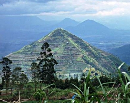
The Sadahurip Pyramid, Garut, Indonesia
THE SPIRIT POND RUNESTONES
Information Compiled by the Faram Research Foundation
This information is released into the Public Domain provided the credits remain with any part of the presentation.
The Spirit Pond Runestones were three stones found in Maine in 1977. One stone bears a rough map of a seacoast area. Another stone has six lines of runic writing on one side and ten lines of runic writing on the other side. The third stone bears runes that tell of a sudden storm and fearful men trying to save their ship from the foamy arms of Aegir, the angry God of the sea. These stones have been called a hoax by many. Alf Monge, an army cryptographer and author of the book Solutions to Runic Cryptograms - 1980, believes, as do I, that the stones are genuine. After reading the following text you may also come to that same conclusion.
16 LINE SPIRT POND RUNESTONE
In the following text you will be presented 49 European names. These are most likely the names of the seamen which were the crew of the subject ship, and whose names were engraved for posterity on one of the stones. Some of them may have lost their lives in the storm. All the names were translated using The Younger Futhork rune translation. This conglomeration of names would have confused even the most studied academic unless they were looking for names rather than a coherent text. To further confuse the translator the names are derived from 18 separate ethnic backgrounds. The process that was used to resolve the mystery was to translate the runes to English letters. Since the names are separated by a : sign it was easy to know where to start and end the names.
The task then was to research all the names and see if they made any sense, and to determine where they originated. The findings were very gratifying. Most of the names were found to be legitimate names from many ethnic backgrounds. Although there were at least 18 different ethnic backgrounds represented, all the locations were ports or locations that the Celts and Norse were known to have visited during their travels. During earlier times it was not uncommon to take on seamen, from various ports, as ships sailed around the world. To further validate that these might be the names of the crew, Celtic and Scandinavian ships were known to carry 40 to 50 men on their larger ships. The date of 1002 CE inscribed on one of the stones coincides with the banning of the Vikings from their homeland of Norway. They were banned after they attacked Norway for adopting Catholicism. At the time the Danish Celts and the Vikings were allies. However, in the 14th Century non-Viking Norse began migrations to North America. The Celts, having a major stake in North America then became an adversary of the Norse. Most, but not all, of pre-Columbian migration to the US has been destroyed for political reasons.
In the following text you will be presented with 49 European names. These are most likely the names of the seamen which were the crew of the subject ship, and whose names were engraved for posterity on one of the stones. Some of them may have lost their lives in the storm. All the names were translated using The Younger Futhork rune translation. This conglomeration of names would have confused even the most studied academic unless they were looking for names rather than a coherent text. To further confuse the translator the names are derived from 18 separate ethnic backgrounds. The process that was used to resolve the mystery was to translate the runes to English letters. Since the names are separated by a : sign it was easy to know where to start and end the names.
Seamen Listed on One of the Spirit Pond Stones
(The numbers are believed to be the coordinates of the place where they came ashore.)
Younger Futhork
Younger Futhork or "Normal Runes" gradually evolved from the Elder Futhark over a period of many years and stabilized by about 800 CE. It was the main alphabet in Norway, Sweden and Denmark throughout the Celtic-Viking alliance, but was not completely replaced by the Latin alphabet until about 1200 AD. This change was the result of the conversion of most of Scandinavia to Christianity.
Three slightly different versions of the runic alphabet developed in Denmark, Sweden and Norway. Research, by the Faram Foundation, shows that the party that would have carved the Maine Runestones most likely originated from a country that was a member of the Norway Denmark Alliance. (The Norway-Denmark Alliance consisted of; Norway, Celtic Denmark, and Scotland.) The Scandinavian alliance existed during the time period that the stones would have been carved. This would make Younger Futhork the logical rune translator.
Younger Futhark Runes:
Danish Futhark
The Yonaguni Pyramid
Swedish-Norwegian / Short-twig / Rök Runes
Swedish-Norwegian Runes
Norwegian Futhark
Norwegian Futhark
Gothenburg / Bohuslän Runes
Gothenburg-Bohusln Runes
The Map Stone
The Map, of a Seacoast, Engraved on the Map Stone
(Compare to the following image.)
The Coast of Portsmouth New Hampshire, Which Matches the Map on the Stone
NOTE: On this image the land at the entrance to the river is restored in pen to match the Spirit Stone map. Due to its location this peninsula would have been vulnerable to the currents of both the river and the ocean. Over time this would have eroded the land away.
The coordinates engraved on the Map stone are just north of Portsmouth, in Maine.
In the following image is a translation inscribed from runes on the Map stone and transcribed as S10 Na4 UMF6. Just by looking at the figures they look like coordinates of some sort. By using old maps, which have the curious compass circles with the compass lines projected from them, we were able to find the proper radials which crossed at the spot marked by the X on the photo. But that is not all. The spot marked lies directly on the 090 degree radial, the sacred radial reserved for objects of importance, extending from the spot where the Kensington Runestone was discovered. Could this be a map to make sure the Kensington Runestone would be found in the future? Could the stone with the map have been carved after the other two stones were carved? There are Geoglyphs that exist on the seashore just north of the location marked by the X. Incidentally, the area just north of there is named Salisbury. Salisbury is the same name of the area where the geoglyph named Stonehenge is located. Are these all coincidences?
The Mysterious Coordinates
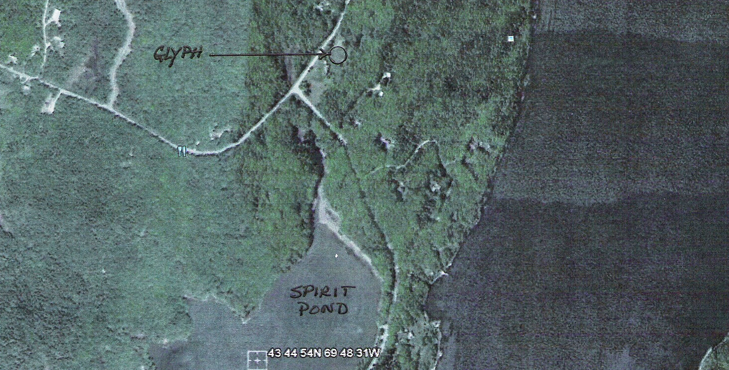
The Geoglyph Near Spirit Pond
Where the Spirit Pond Stones Were Found
If you will notice in the image the spot where a Geoglyph was found lies near where the stones were found. The stones may have been carried north to this location, from Southern Maine by the originators. The geoglyphs located here match the protocols of the ancient science of Geoglyphology found in Western Europe and elsewhere around the world. (Ref: http://www.thefaramfoundation.com )
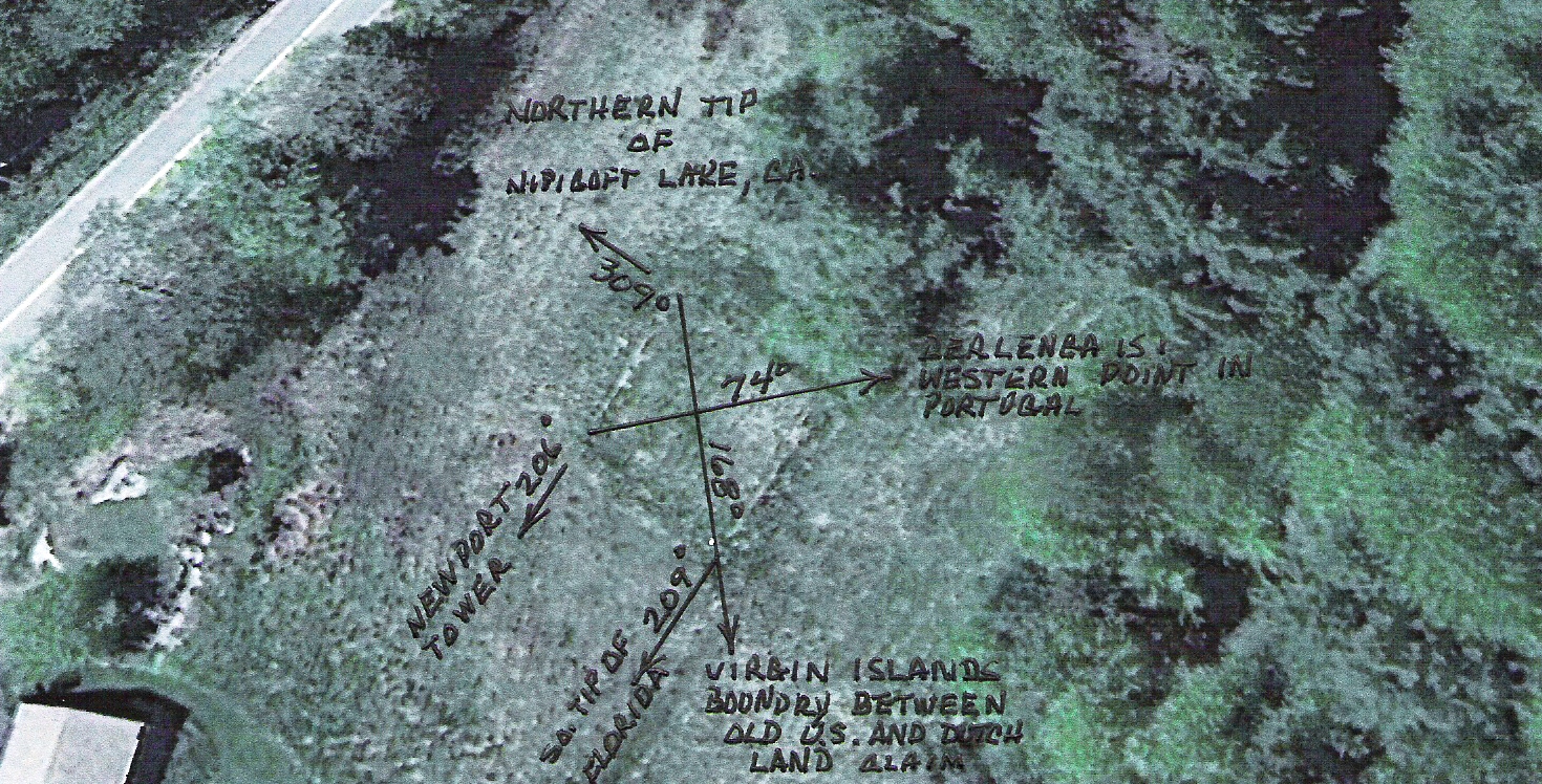
The following image shows the Geoglyph as it points to places which were important to the builders. The importance of the radials emanating from the Spirit pond Geoglyph cannot be understated. For example; Fort Adams, RI, commissioned on July 4th 1799 is a Geoglyph, as are many forts and monuments around the world. This shows that our founding fathers knew about the science of Geoglyphology. The walls of Fort Adams point to many places that were important to the founders of our country. The most validating point is the fact that the places to which the Spirit Pond Geoglyph points are also included in the Fort Adams Geoglyph, which incidentally is located in Newport, Rhode Island, one of the locations identified by the Spirit Pond Geoglyph.
The Spirit Pond Geoglyph Radials
These are the bearings/radials which appear in both the Spirit Pond and the Fort Smith geoglyphs. Magnetic bearings can be taken at the point of origin, however; in order to project them out one must use a true bearing to eliminate magnetic deviation. This will create a great circle route. All radials, the extended version of the bearings, were calculated using a great circle route then the ends were connected with a straight line for simplicity.
The bearings illustrated in the preceding image would not mean much to the normal person, unless the history behind them were studied beforehand. The history of the radials follows:
074 Degree Radial Berlinga Island, Portugal. Berlinga Island is the Western most point in Portugal. This point is used many times in geoglyphs around the world. The point meets one of the protocols of Geoglyphology which was established by the ancients. The Celts and Portuguese had been partners since they joined forces to fight the Roman Republic, their name before the Roman Empire, in Northern Italy c800 BC. The Portuguese were known as the Etruscans at the time.
After eventually losing battles to the Roman Empire the Etruscans moved to Portugal and the Celts moved to Galicia, now part of Spain. The Portugal/Galician border is the oldest border of established countries in Europe.
168 Degree Radial The southeast corner of a territory granted to the Templars, by Portugal, for helping Spain and Portugal rid the Iberian Peninsula of the Moors. Prior to the grant to the Templars, Portugal, previously the Etruscans, claimed all of North and South America, and they had built the survey markers to prove it. If you will look on the famous Juan de La Cosa Map you will see twenty seven small circles with a dot in the center which appear along the shores of North and South America. Those circles are geoglyphs placed in the Americas to prove that the Portuguese had established a claim to the Americas. (The circles, and surveys of the circles, can be seen in the book Ancient Signposts by Arthur Faram - 2011) That is why the Portuguese were able to grant a portion of North America to the Templars, later called the Free masons. This territory later became the United States. The territory which Portugal granted was larger than the current US boundaries. The northern border is only slightly changed. The southern border changed in the Treaty of Guadalupe after the Mexican/American war. The southern border used to extend from the island of San Salvador, where coincidentally Columbus landed, to the tip of Baja California.
209 Degree Radial The southern tip of Florida. The South East corner of the land mass we now know as the US.
206 Degree Radial Newport Island, Newport, RI USA. Newport Island has been an important and sacred place to all enlightened cultures which came to North America over thousands of years. The 7000 year old Gulpho de Cintra geoglyphs in western Africa, the Chinese Pyramids c545 BC, and countless other geoglyphs point to Newport Island. The island was even mentioned in the book 1421: The Year China Discovered the World, by Gavin Menzies.
309 Degree Radial Northern tip of Nipigon Lake. Currently on the US/Canadian border. Many people do not realize, that after the British/American war, the Treaty of Paris granted the US only the land east of the Mississippi River. Nipigon Lake served as the Northwest corner of this territory. Spain took advantage of this oversight and took the western US for themselves. This land was recovered through the Louisiana Purchase and the Mexican/American war.